|
| bool | AxMap.DegreesToPixel (double degreesLngX, double degreesLatY, ref double pixelX, ref double pixelY) |
| | Converts pixel coordinates to decimal degrees (map projection must be specified for this method to work). More...
|
| |
| bool | AxMap.DegreesToProj (double degreesLngX, double degreesLatY, ref double projX, ref double projY) |
| | Converts coordinates in decimal degrees to projected map coordinates (map projection must be specified for this method to work). More...
|
| |
| double | AxMap.GeodesicArea (Shape polygon) |
| | Calculates area of polygon taking into account the shape of Earth. More...
|
| |
| double | AxMap.GeodesicDistance (double projX1, double projY1, double projX2, double projY2) |
| | Calculates geodesic distance between 2 points defined in map coordinate system. More...
|
| |
| double | AxMap.GeodesicLength (Shape polyline) |
| | Calculates length of polyline or perimeter of polygon taking into account the shape of Earth. More...
|
| |
| bool | AxMap.PixelToDegrees (double pixelX, double pixelY, ref double degreesLngX, ref double degreesLatY) |
| | Converts coordinates in decimal degrees to pixel coordinates (map projection must be specified for this method to work). More...
|
| |
| void | AxMap.PixelToProj (double pixelX, double pixelY, ref double projX, ref double projY) |
| | Converts pixel coordinates to projected map coordinates More...
|
| |
| bool | AxMap.ProjToDegrees (double projX, double projY, ref double degreesLngX, ref double degreesLatY) |
| | Converts projected map coordinates to decimal degrees (map projection must be specified for this method to work). More...
|
| |
| void | AxMap.ProjToPixel (double projX, double projY, ref double pixelX, ref double pixelY) |
| | Converts projected map coordinates into screen pixel units More...
|
| |
|
| tkCustomDrawingFlags | AxMap.CustomDrawingFlags [get, set] |
| | Set custom drawing flags More...
|
| |
| DrawingRectangle | AxMap.FocusRectangle [get] |
| | For selection boxes or dragging operations, updated with tkRedrawType.Minimal More...
|
| |
| GeoProjection | AxMap.GeoProjection [get, set] |
| | Gets or sets projection for map. More...
|
| |
| bool | AxMap.GrabProjectionFromData [get, set] |
| | Gets or sets a value indicating whether projection for will be taken from the first datasource added to it. More...
|
| |
| SelectionList | AxMap.IdentifiedShapes [get] |
| | Get the identified shapes More...
|
| |
| tkUnitsOfMeasure | AxMap.MapUnits [get, set] |
| | Gets or sets the units of measure for the map. More...
|
| |
| Measuring | AxMap.Measuring [get] |
| | Gets measuring object associated with map. More...
|
| |
| double | AxMap.PixelsPerDegree [get, set] |
| | Gets the number of screen pixels per the decimal degree of the data. More...
|
| |
| tkMapProjection | AxMap.Projection [get, set] |
| | Sets projection of the map. It providers 2 most commonly used coordinate system/projections to be easily set from Form Designer. To set other projections initialize GeoProjection object manually and use AxMap.GeoProjection property. More...
|
| |
| tkScalebarUnits | AxMap.ScalebarUnits [get, set] |
| | Gets or sets units to be displayed for map scalebar. More...
|
| |
| bool | AxMap.ScalebarVisible [get, set] |
| | Gets or sets a value which indicate whether scalebar will be displayed on the map. More...
|
| |
| tkCoordinatesDisplay | AxMap.ShowCoordinates [get, set] |
| | Gets or sets a value indicating whether coordinates of the current mouse position will be displayed on map. More...
|
| |
| bool | AxMap.ShowCoordinatesBackground [get, set] |
| | Gets or sets a value indicating whether to display a white background behind the coordinates, for better contrast More...
|
| |
| tkAngleFormat | AxMap.ShowCoordinatesFormat [get, set] |
| | Allows to format coordinates in top right corner in degrees/minutes/seconds format; by default the former minutes format is used More...
|
| |
Here is list of properties and methods which are related to coordinate system, projection of map and units conversion. This module is a part of the documentation of AxMap class.
Graph description
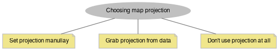
A. Setting projection for the map.
No matter what type of GIS application you are going to write, the decision about map coordinate system and projection is one of the first to be made. MapWinGIS provides the following options.
Let's consider each of the approaches.
1. Settings projection manually.
It can be done using one of the following approaches:
a) AxMap.Projection property - provides only most common projections (Spherical Mercator, WGS84) but available in Properties Window of Form designer.
tkMapProjection
Commonly used map projections to be set in Form Designer (see AxMap.Projection property).
Definition: Enumerations.cs:1741
b) For all other projections - GeoProjection class and AxMap.GeoProjection property:
gp.ImportFromEPSG(2399);
gp.ImportFromAutoDetect("+proj=sterea +lat_0=52.15616055555555 +lon_0=5.38763888888889 +k=0.9999079 +x_0=155000 +y_0=463000 +ellps=bessel +units=m +no_defs ");
axMap1.GeoProjection = gp;
tkWgs84Projection
Definition: Coordinate systems.cs:715
tkCoordinateSystem
Definition: Coordinate systems.cs:4
GeoProjection GeoProjection
Gets or sets projection for map.
Definition: AxMap.cs:2719
2. Grabbing coordinate system and projection from data.
axMap1.GrabProjectionFromData = true;
axMap1.AddLayerFromFilename(
@"d:\some_shapefile.shp",
tkFileOpenStrategy.fosVectorLayer,
true);
tkFileOpenStrategy
Possible open strategies for datasources.
Definition: Enumerations.cs:1799
GeoProjection will be taken from the first layer added to the map which has metadata about projection. AxMap.GeoProjection property will be updated from this metadata. When last layer is removed from map AxMap.GeoProjection property will be cleared (set to empty projection).
3. Don't specify coordinate system at all.
- AxMap.Projection property is equal to PROJECTION_NONE (the default value);
- map units should be set manually via AxMap.MapUnits;
- calculation of distance and area will use Euclidean geometry with no account to the shape of Earth;
- it won't be possible to display tiles from TMS servers.
To setup map to work without geoprojection use the code:
axMap1.GrabProjectionFromData = false;
tkUnitsOfMeasure
The possible units of measure for the data being displaying on map.
Definition: Enumerations.cs:1397
B. Interaction with already set projection
To check that map actually has a projection:
Debug.WriteLine(
"Map has projection:" + (axMap1.Projection !=
tkMapProjection.PROJECTION_NONE));
Debug.WriteLine("Projection of the map: " + (axMap1.GeoProjection.IsEmpty() ? "None" : axMap1.GeoProjection.ExportToWKT());
Another way to check whether map has geoprojection is to see how coordinates are displayed when AxMap.ShowCoordinates is set to cdmAuto. In case decimal degrees are displayed (Lat/Lng) - map has geoprojection, if x/y pair is shown - no geoprojection was set.
All of these methods will result in updating AxMap.GeoProjection property. GeoProjection object assigned to map is protected from changes, i.e. GeoProjection.IsFrozen = true. To change already assigned projection, a new instance of GeoProjection object must be created:
if (!axMap1.GeoProjection.ImportFromEPSG(2399))
{
Debug.WriteLine("Projection wasn't set: " + axMap1.GeoProjection.get_ErrorMsg(axMap1.GeoProjection.LastErrorCode));
}
var gp = axMap1.GeoProjection.Clone();
if (gp.ImportFromEPSG(2399))
{
axMap1.GeoProjection = gp;
}
Regardless of the method for settings projection MapWinGIS will update AxMap.MapUnits. IF coordinate system is geographic one umDecimalDegrees will be set, otherwise umMeters. This will ensure that scalebar and measuring will work correctly.
C. Choosing projection
When making decision about coordinate system and projection consider:
- Whether it's important to display tiles from online services. Most TMS servers use Shperical Mercator projection (EPSG:3857), therefore to avoid distortions of tiles map projection should be set to GoogleMercator as well:
- Note
- See more details on the issue in description of Tiles class.
- What data you plan to display and what projection it's using. It's possible to do a reprojection with:
But it should be considered whether it is worth the effort.
Starting from version 4.9.2. built-in projection mismatch testing is implemented + optional transformation for shapefiles. See GlobalSettings.AllowProjectionMismatch, GlobalSettings.ReprojectLayersOnAdding.
◆ DegreesToPixel()
| bool AxMap.DegreesToPixel |
( |
double |
degreesLngX, |
|
|
double |
degreesLatY, |
|
|
ref double |
pixelX, |
|
|
ref double |
pixelY |
|
) |
| |
Converts pixel coordinates to decimal degrees (map projection must be specified for this method to work).
- Parameters
-
| degreesLngX | Longitude in decimal degrees. |
| degreesLatY | Latitude in decimal degrees. |
| pixelX | Converted X screen coordinate. |
| pixelY | Converted Y screen coordinate. |
- Returns
- True on success.
- New API 4.9.1:
- Added in version 4.9.1
◆ DegreesToProj()
| bool AxMap.DegreesToProj |
( |
double |
degreesLngX, |
|
|
double |
degreesLatY, |
|
|
ref double |
projX, |
|
|
ref double |
projY |
|
) |
| |
Converts coordinates in decimal degrees to projected map coordinates (map projection must be specified for this method to work).
- Parameters
-
| degreesLngX | Longitude in decimal degrees. |
| degreesLatY | Latitude in decimal degrees. |
| projX | Resulting projected X map coordinate. |
| projY | Resulting Projected Y map coordinate. |
- Returns
- True on success.
- New API 4.9.1:
- Added in version 4.9.1
◆ GeodesicArea()
| double AxMap.GeodesicArea |
( |
Shape |
polygon | ) |
|
Calculates area of polygon taking into account the shape of Earth.
For the time being only single-part polygons are accepted as input. Calculation are made using GeographicLib.
- Parameters
-
| polygon | Single part polygon shape defined in coordinates of map. |
- Returns
- Area of shape in square meters or 0.0 if current map projection doesn't support transformation to WGS84.
- New API 4.9.3:
- Added in version 4.9.3
◆ GeodesicDistance()
| double AxMap.GeodesicDistance |
( |
double |
projX1, |
|
|
double |
projY1, |
|
|
double |
projX2, |
|
|
double |
projY2 |
|
) |
| |
Calculates geodesic distance between 2 points defined in map coordinate system.
To calculate geodesic distance between 2 points in screen coordinates use AxMap.PixelToProj first. Calculation are made using GeographicLib.
- Parameters
-
| projX1 | X coordinate of the first point. |
| projY1 | Y coordinate of the first point. |
| projX2 | X coordinate of the second point. |
| projY2 | Y coordinate of the second point. |
- Returns
- Distance between 2 points in meters 0.0 if current map projection doesn't support transformation to WGS84
- New API 4.9.3:
- Added in version 4.9.3
◆ GeodesicLength()
| double AxMap.GeodesicLength |
( |
Shape |
polyline | ) |
|
Calculates length of polyline or perimeter of polygon taking into account the shape of Earth.
For the time being only single-part shapes are accepted as input. Calculation are made using GeographicLib.
- Parameters
-
| polyline | Single part polygon or polyline shape defined in coordinates of map. |
- Returns
- Length of polyline or perimeter of polygon in meters or 0.0 if current map projection doesn't support transformation to WGS84.
- New API 4.9.3:
- Added in version 4.9.3
◆ PixelToDegrees()
| bool AxMap.PixelToDegrees |
( |
double |
pixelX, |
|
|
double |
pixelY, |
|
|
ref double |
degreesLngX, |
|
|
ref double |
degreesLatY |
|
) |
| |
Converts coordinates in decimal degrees to pixel coordinates (map projection must be specified for this method to work).
- Parameters
-
| pixelX | X screen coordinate. |
| pixelY | Y screen coordinate. |
| degreesLngX | Converted longitude in decimal degrees |
| degreesLatY | Converted latitude in decimal degrees |
- Returns
- True on success.
- New API 4.9.1:
- Added in version 4.9.1
◆ PixelToProj()
| void AxMap.PixelToProj |
( |
double |
pixelX, |
|
|
double |
pixelY, |
|
|
ref double |
projX, |
|
|
ref double |
projY |
|
) |
| |
Converts pixel coordinates to projected map coordinates
- Parameters
-
| pixelX | The x pixel coordinate to be converted into the projected x map coordinate. |
| pixelY | The y pixel coordinate to be converted into the projected y map coordinate |
| projX | The projected x map coordinate is returned through this reference parameter. |
| projY | The projected y map coordinate is returned through this reference parameter. |
- Examples
- EditAttributes.cs, MarkPoints.cs, RemoveShape.cs, SelectBox.cs, and ToolTip.cs.
◆ ProjToDegrees()
| bool AxMap.ProjToDegrees |
( |
double |
projX, |
|
|
double |
projY, |
|
|
ref double |
degreesLngX, |
|
|
ref double |
degreesLatY |
|
) |
| |
Converts projected map coordinates to decimal degrees (map projection must be specified for this method to work).
- Parameters
-
| projX | Projected X map coordinate. |
| projY | Projected Y map coordinate. |
| degreesLngX | Converted longitude in decimal degrees |
| degreesLatY | Converted latitude in decimal degrees |
- Returns
- True on success.
- New API 4.9.1:
- Added in version 4.9.1
◆ ProjToPixel()
| void AxMap.ProjToPixel |
( |
double |
projX, |
|
|
double |
projY, |
|
|
ref double |
pixelX, |
|
|
ref double |
pixelY |
|
) |
| |
Converts projected map coordinates into screen pixel units
- Parameters
-
| projX | The projected x map coordinate to be converted into the x pixel coordinate. |
| projY | The projected y map coordinate to be converted into the y pixel coordinate. |
| pixelX | The pixel x coordinate is returned through this reference parameter |
| pixelY | The pixel y coordinate is returned through this reference parameter. |
- Examples
- Tracking.cs.
◆ CustomDrawingFlags
◆ FocusRectangle
For selection boxes or dragging operations, updated with tkRedrawType.Minimal
◆ GeoProjection
◆ GrabProjectionFromData
| bool AxMap.GrabProjectionFromData |
|
getset |
◆ IdentifiedShapes
Get the identified shapes
◆ MapUnits
◆ Measuring
Gets measuring object associated with map.
- New API 4.9.1:
- Added in version 4.9.1
◆ PixelsPerDegree
| double AxMap.PixelsPerDegree |
|
getset |
Gets the number of screen pixels per the decimal degree of the data.
The set part of this property isn't supported. The correctness of results depends on AxMap.MapUnits property.
- New API 4.8:
- Added in version 4.8
◆ Projection
Sets projection of the map. It providers 2 most commonly used coordinate system/projections to be easily set from Form Designer. To set other projections initialize GeoProjection object manually and use AxMap.GeoProjection property.
- New API 4.9.1:
- Added in version 4.9.1
- Examples
- AddCategoryRange.cs, CalculateArea.cs, CreateBuffer.cs, CreatePointShapefile.cs, CreatePolygonShapefile.cs, EditAttributes.cs, GenerateLabelsManually.cs, ImageLabels.cs, IntersectionLength.cs, LabelSelection.cs, LinePattern.cs, MarkPoints.cs, MinimalDistance.cs, PointIcons.cs, PolygonsWithHoles.cs, RemoveShape.cs, Segmentation.cs, SelectBox.cs, SelectByDistance.cs, SelectByQuery.cs, ShapefileToDrawingLayer.cs, ShowAttributes.cs, SplitByAttribute.cs, ToolTip.cs, TrackCars.cs, Tracking.cs, and ZoomToValues.cs.
◆ ScalebarUnits
Gets or sets units to be displayed for map scalebar.
- New API 4.9.1:
- Added in version 4.9.1
◆ ScalebarVisible
| bool AxMap.ScalebarVisible |
|
getset |
Gets or sets a value which indicate whether scalebar will be displayed on the map.
- New API 4.9.0:
- Added in version 4.9.0
◆ ShowCoordinates
Gets or sets a value indicating whether coordinates of the current mouse position will be displayed on map.
- New API 4.9.1:
- Added in version 4.9.1
◆ ShowCoordinatesBackground
| bool AxMap.ShowCoordinatesBackground |
|
getset |
Gets or sets a value indicating whether to display a white background behind the coordinates, for better contrast
- New API 5.2:
- Added in version 5.2
◆ ShowCoordinatesFormat
Allows to format coordinates in top right corner in degrees/minutes/seconds format; by default the former minutes format is used